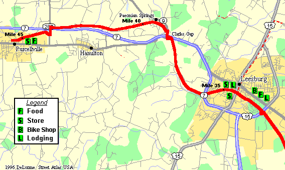
This section begins just west of Ashburn, VA. At mile 31, the high voltage power lines ended at a substation, so the trail is much more shady. The next few miles are rather secluded (or used to be). At mile 33, the trail makes several sharp turns in order to cut underneath the Route 15 Leesburg Bypass. Use caution here on the corners due to limited sight distance.

W&OD Trail Mile 32 thru 45 |
The trail then enters the Leesburg area. About a mile later the trail crosses Catoctin Circle, one of the worst intersection crossing on the trail. There is a bike shop and several restaurants about a quarter mile north of the trail. At mile 34.5, the trail crosses Business Route 15 in downtown Leesburg.
From here, you can follow Route 15 north for about 3 miles to Whites Ferry, in order to cross the Potomac River into Maryland.
Business 15 marks the start of a four mile long gradual climb over Catoctin Mountain through Clark's Gap. Despite the climb, this final 10 mile section of the trail between Leesburg and Purcellville is by far the nicest. The trail winds through some very scenic terrain, and is mostly shaded. The trail crosses Route 7 twice, at Clark's Gap and a few miles later at Route 287. At mile 44, the trail passes Loudoun Valley High School (at the Water Tower). There are several restaurants and convenience marts about a half mile south of the trail at this point. The trail ends in downtown Purcellville at Route 690, about one block north of Business Route 7. The total trail length is 45.5 mile.
| <<< Prev Page | Next Page >>> |